Ruminations

Blog dedicated primarily to randomly selected news items; comments reflecting personal perceptions

Sunday, March 22, 2026

Coming Home to Odaka, Fukushima Prefecture
https://s.hdnux.com/photos/01/65/34/73/30789323/3/960x0.webp
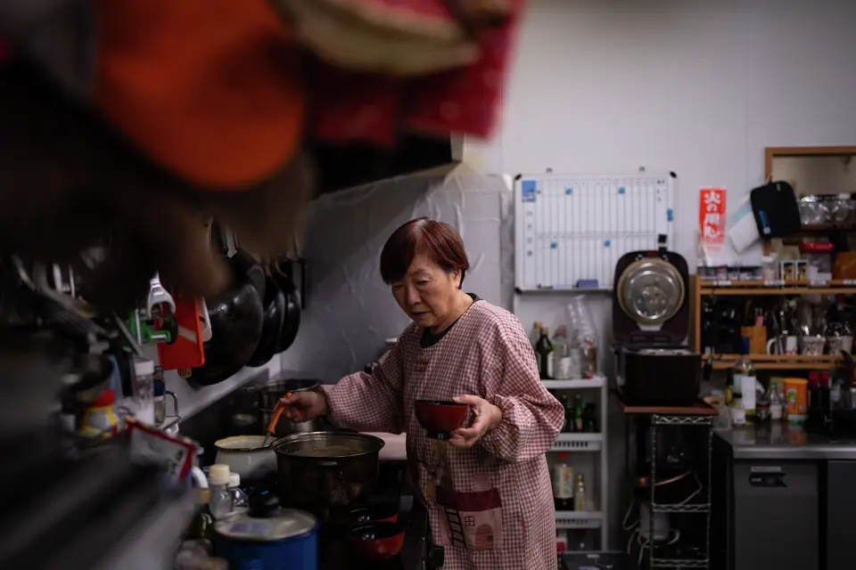
Tomoko Kobayashi serves miso soup during breakfast service at Futabaya Ryokan in Odaka, Fukushima Prefecture, Friday, Feb. 13, 2026, Louise Delmotte/AP 
"These empty lots used to be filled with shops. There used to be businesses, community activity and children playing. We used to live our ordinary daily lives here, and I hope to see that again."
"The town was destroyed, and we need to rebuild it. It's a time-consuming process that cannot be accomplished in just a couple of decades."
"But I hope to see the progress, with new people and new development added to what this town used to be." 
Tomoko Kobayashi, Odaka, northeastern Fukushima, Japan 
Fifteen years have passed since Japan's 2011 nuclear disaster at the Fukushima Nuclear Plant, after a tsunami followed an earthquake to turn Japan's sense of security over energy derived from nuclear inside out and upside down. In Odaka, a town nearby the nuclear plant, the Kobayashi family still operate the family inn, the Futabaya Ryokan, in the near-deserted town. Tomoko Kobayashi, dedicated to rebuild the town to what it once was, conducts radiation surveys. She did just that before the family reopened their inn in 2016.
 
She and other monitors obsessed with recovering the town and its environs, share radiation data in their efforts to reconstitute the town once known as a textile hub. The magnitude 9.0 quake off Japan's northwestern coast in 2011 is a memory that Tomoko will not ever forget; that of long, violent shaking of the inn's walls. Then, an hour later the tsunami struck and water surged into the inn's kitchen "like a river". A far more destructive wave hit the Fukushima Dai-ichi nuclear plant, destroying key cooling systems and causing a meltdown at three reactors. 
"I had to understand what the nuclear accident was about. I thought someone had to go back and keep an eye out. Now it has become my lifetime mission."
"We are not professional scientists, but we can measure and show the data. What's important is to keep measuring, because the government maintains that it's safe, as if radiation no longer exists."
"But we know for a fact that it's still there."
Tomoko Kobayashi 
  Guests from near and far at Futabaya Ryokan
Guests from near and far at Futabaya Ryokan   Fukushima Fieldwork Report
 
A day later, the No. 1 reactor building suffered a hydrogen explosion and two days after that, the Unit 3 reactor building exploded, followed by the No. 4 reactor building spewing radioactive particles contaminating the surroundings, causing hundreds of thousands of residents to flee their homes and all that was familiar to them. Tomoko and her husband, after two years of living in Nagoya, returned to the area in 2012, to live nearby in temporary housing accommodation.  
 
Since then the town had recovered somewhat. The operated their inn and at the same time continued to measure the radiation levels in the soil, as they do now, a decade later. Twice yearly, Tomoko and others like her interested in returning to the town and opening new businesses, set aside two weeks to measure the air at hundreds of locations to enable them to produce colour-coded maps that reflect the radiation data in the areas they measure. They've set up a lab where local produce is tested to ensure that what they eat is safe.
 
https://halifax.citynews.ca/wp-content/blogs.dir/sites/5/2026/03/f54b993828cddfa3dbe6fde116a77a77679d5210a02db9f219fc2f1cae891958-1024x682.jpg
Tomoko Kobayashi looks at a color-coded map of radiation levels created by local residents during an interview near a radiation monitoring lab in Odaka. (AP Photo/Louise Delmotte) 
 
The nuclear plant has seawalls built around it for the purpose of withstanding another massive tsunami. All of the plant's reactor buildings have enclosed rooftops. "Our decommissioning work at the plant is about how to reduce risks of radiation", explains head of decommissioning, Akira Ono from Tokyo Electric Power Holdings Company, the plant operator. Between them the three reactors contain some 880 tons of melted fuel debris whose radiation levels remain dangerously high. 
 
Fukushima prefecture says all farm, fisheries and dairy products in stores are safe, having tested thousands of predistribution samples annually. At the same time harvests of fruits, mushrooms, river fish in former no-go zones remain restricted. "Radiation levels have come down significantly over the past 15 years, but I wouldn't use the word 'safe', just yet", former decontamination and radiation survey at Fukushima Dai-ichi, Yukio Shirahige, added. In testing wild boar meat it was found to be 100 times over the safety limit of contamination.
 
Getting a close look at Unit 2 and Unit 3 at Daiichi NPP
Getting a close look at Unit 2 and Unit 3 at Daiichi NPP  Fukushima Fieldwork Report
 
Now, since 2022, Japan has new plans to accelerate reactor restarts to bolster nuclear power as a stable energy source.  

Labels: , , , , , ,

Monday, January 17, 2022

Hunga Tonga Undersea Volcano : Violent Eruption

"We have a  nightmare situation of an isolated community experiencing the effects of a large volcanic ash plume producing significant volcanic lightning, as well as a tsunami."
"Seeing that ash plume, that volcanic lightning, and that tsunami leave me feeling sick thinking about the people being impacted by this large eruption."
Janine Krippner, volcanologist, Smithsonian Global Volcano Program
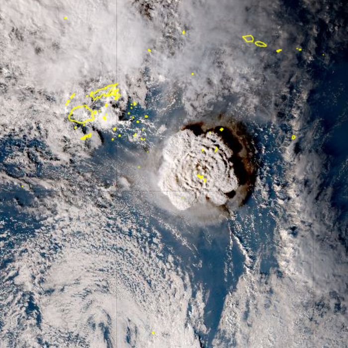
Satellite image of eruption of the Hunga Tonga Hunga Ha’apai volcano on Saturday. Photo: Himawari-8/Japan Meterological Agency
 
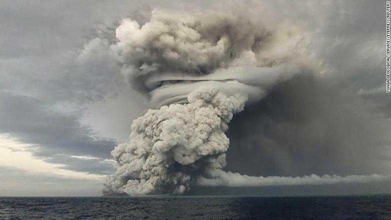
How large, how powerful? The ash and smoke plume from Hunga Tonga volcano covered a vast area, the plume thick enough to blot out the sun, though this was a night-time eruption. Within the plume static discharges towered twice the height of Earth's most fiercely volatile thunderstorms, the result of which was barrages of volcanic lightning striking out of pyrocumulonimbus clouds produced by volcanoes. 
 
It is not yet known how much danger Tongans faced, how many people may have died if any or been injured, much less the damage to infrastructure.

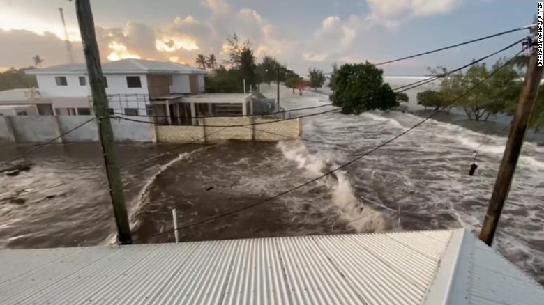
Sensitive lightning detection networks and satellites following the volcano's initial blast counted the equivalent of 70 lightning strikes per second. A tsunami of several metres was generated by the powerful blast, leading to warning of tsunami advisories for Tongans to immediately seek higher ground. Advisories were also promulgated across Hawaii, Alaska, British Columbia and the west coast of North America; Washington, Oregon and California included.
 
Ash rises into the air after a powerful underwater volcanic eruption in the South Pacific.
 
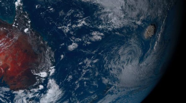
"Gravity waves" captured by satellite imagery were seen rippling outward from the area that the plume punctured in the layer of the lower atmosphere. The result was dense perturbations sent outward similar to waves surrounding a stone tossed into a lake.The volcano, located about 65 kilometres north of the main island of Tongatapu in the southwest Pacific explosively erupted Saturday evening sending ash 100,000 feet in height, generating an atmospheric shock wave rippling across the globe.
 
The eruption was heard in Alaska, 8,000 kilometres distant from Tonga. Home to 135,000 people, Tonga is northeast of New Zealand, southeast of Fiji. There is speculation that the volcano could be responsible for affecting the Earth's climate. Atmospheric scientists are collecting data to determine what role the volcano's eruption can produce atmospherically across the world.
 
Hunga Tonga is an active underwter volcano which erupts from time to time; as it did in 2009, in 2014 and in December of 2021. Since the December eruption it has sporadically exhibited spurts of activity Until January 15 when an especially explosive eruption occurred to produce the most remarkably striking display of volcanic power that weathere satellites captured.
 
A tsunami has hit Tonga's largest island, Tongatapu.

The plume the eruption produced was spectacularly towering, reaching a height of 30,500 metres, approximately three times the altitude a commercial aircraft achieves in flight.  Tonga's plume was buoyant enough to earn it the capacity to penetrate the lowest level of Earth's atmosphere and from there continue to pierce the stratosphere until pockets of air and ash subsided.
 
Experts at the National Weather Service in Anchorage and University of Alaska Fairbanks confirmed reports of audible booms early Saturday in Alaska that originated from the volcano. A phenomenon that affirms the sound travelled at close to 1,300 km/h. Much of the sound produced fell within the spectrum of what can be detected by humans.
"It’s not yet clear how powerful the eruption was or what long-term impact it could have. Volcanologists have developed a scale that describes the size of explosive volcanic eruptions based on magnitude and intensity — the volcanic explosivity index, or VEI. Prior eruptions from the undersea volcano near the nation of Tonga were 2. (For context, Krakatoa’s 1883 eruption, which was one of the most deadly volcanic eruptions of modern history, had a VEI of 6.)"
"But while some experts predict Saturday morning’s eruption could be, at least, a VEI of 4, it’s too soon to tell. “Until we know how much material has been ejected (made harder by the underwater component), we can’t use the scale,” volcanologist Jess Phoenix tweeted. “This means that while we know this eruption is consequential, we won’t have all the info on it for a while.” Since the eruption is still ongoing, there could be more explosions, collapses, and tsunamis to come — or this could be it for a while."
Intelligencer
Our research into these earlier eruptions suggests this is one of the massive explosions the volcano is capable of producing roughly every thousand years. (NICT via AP)
 

Labels: , , , , ,

Saturday, September 30, 2017

An Extraordinary Four-Year Migration

This April 2015 photo shows marine sea slugs from a derelict vessel from Iwate Prefecture, Japan, that washed ashore in Oregon.
This April 2015 photo shows marine sea slugs from a derelict vessel from Iwate Prefecture, Japan, that washed ashore in Oregon. (John W. Chapman/Associated Press)

"It's a bit of what we call ecological roulette."
"We think that earlier tsunamis were contributing mostly, to the ocean, essentially biodegradable material: wood and trees which don't last nearly as long, of course, as does the plastic material."
"The diversity was somewhat jaw-dropping. Mollusks, sea anemones, corals, crabs, just a wide variety of species, really a cross-sectiion of Japanese fauna."
"Most of the species were, in fact, novel and not found in North America or the Hawaiian islands."
"When that first dock arrived, [floating in from Japan post-2011Tsunami] it was just 100 per cent covered with tens of thousands of mussels from Japan, and just draped with kelp."
"How many species started the trip we don't know and how many were lost in the tsunami is hard to know."
James Carlton, marine sciences professor, Williams College, Williamstown, Massachusetts
Dock Japan tsunami
A Japanese dock covered with marine life from Japan washed up on the Oregon coast. (James Carlton)
"OK, we found something here [she recalls in first encountering the unexpected visitors]. And this isn't from around here, and ... there's some marine life on it."
"It is an international issue," she said. "The ocean definitely showcases that we're all interconnected. There's no boundaries out there with the ocean. We're all in this together."
Karla Robison, environmental and emergency service manager, Ucluelet, British Columbia
 So far there have been no  ewer than a whopping 300 species of fish, mussels and other aqua- creatures discovered to have made their way across the Pacific Ocean taking a trip aboard debris from Japan that washed off the mainland or was whooshed off docking areas as a result of the monumental Japanese tsunami resulting from the powerful 9.1 Richter-scale earthquake that hit the islands in 2011. The flotsam and jetsam may have taken their time, relatively speaking, but for years they've been washing ashore far from their origins.

Researchers have now revealed through a study published in the journal Science, that this mass migration of sea creatures hiking their way along the vast ocean on all manner of vessels and even ocean-bobbing domestic items, represent the longest and largest marine migration ever documented. Scientists have for years collected items washing ashore carrying a wide range of creatures, from beaches in Washington, Oregon, California, British Columbia, Alaska and Hawaii, tracking the sea animals native to Japan.

Now that it has been confirmed that the creatures are far from their natural habitat, concerns have arisen that they will establish themselves as foreign invading species, and possibly eventually succeed in displacing native species. Whether all of the 289 species that have been identified will manage to adjust to their new surroundings and thrive there, eventually making room for themselves at the expense of native creatures, is as yet speculation.
Tsunami Hitchhikers
This June 2012 photo shows Japanese sea stars (Asterias amurensis) on a dock from Misawa, Japan that washed ashore near Newport, Ore. (John W. Chapman/Associated Press)

The very fact that they managed to undertake such a tremendously long voyage over a lengthy period of time is in and of itself fairly astonishing given that researchers estimate that a million creatures made a journey of 7,725 kilometres to cross the Pacific Ocean eventually reaching the West Coast of North America, hundreds of thousands of mussels among them. The previous experience with the invasion of zebra mussels is not one that endears its memory in the opinion of biologists. A repeat would not be a cause for celebration.

Past incidents of marine invasion that been harmful to indigenous farmed shellfish, have caused great disruption and economic losses while eroding the local ecosystem and have caused the spread of disease-carrying species, according to Bella Galil, marine biologist with the Steinhardt Museum of Natural History in Tel Aviv, Israel.

No one could have foreseen that boats, docks, buoys and other such constructed objects would be swept out into the Pacific by an immense tsunami. And even if such an untoward event might have been visualized, nothing could have been done to prevent it. Mother nature disposes. But as the mountain of debris drifted its inexorable way toward North America carrying an army of live creatures, some of which multiplied with new generations while in transit, the deed was done.

And aside from the invasion of foreign species along with the anticipation that complications from their presence will most certainly arise as time wears on, there is the additional disturbing fact that most of the debris that carried those same creatures to Western shores are pallets, crates, buoys and boats constructed of plastic.

Just as the live hitchhikers survived their long journey, the plastics that carried them will survive long afterward to clutter up the world's landscape and add to the pervasive and growing heaps of plastic garbage with all the threats to the environment that they entail.
Tsunami Hitchhikers
This undated photo shows researcher John Chapman inspecting a Japanese vessel that washed ashore on Long Beach, Wash. (Russ Lewis/Associated Press)

Labels: , , , , , , ,

Saturday, December 27, 2014

Waiting For The "Big One"

"In some places there will be maybe 20 minutes before the wave hits."
"The gold standard is what was done in Oregon and that's what we should aim for."
"There is a very clearly defined set of tsunami problems that need to be solved."
Garry Rogers, senior research scientist, Pacific Geoscience Centre, Victoria

"There would be widespread damage, including thousands of injuries and fatalities and the destruction of hundreds of buildings."
"Overall the province [British Columbia] is still at a significant risk if a catastrophic earthquake were to occur today."
British Columbia auditor general report

The dreadful earthquake and following tsunami of horrendous proportions, took the lives of a quarter of a million people in fourteen countries on what was for those countries a truly fateful day in 2004 when Indonesia [200,000 dead, 37,000 missing], India [11,000 dead, 3,000 missing], Sri Lanka [31,000 dead, 4,000 missing] and Thailand [5,400 dead, 3,000 missing] suffered a tragedy of monumental proportions in the Indian Ocean tsunami.

A village near the coast of Sumatra lies in ruins
In the modern era, that incredible loss of life resulting from an upheaval deep within the bowels of the Earth's crust, leading to the aftermath of giant waves washing ashore, was almost matched in intensity by the 2011 earthquake that struck offshore with a 9.0-magnitude force, second to the Indian Ocean's quake that registered 9.1. Japan lies in a well-known earthquake zone; the country uses high-value technology to monitor such events, and the result was a still-considerable loss of 18,000 lives. The situation hugely compounded by a meltdown of five nuclear reactors.

This is an aerial view of damage to Sukuiso, Japan, a week after the earthquake and subsequent tsunami devastated the area in March, 2011.                                                       Credit: Dylan McCord. U.S. Navy

In the Pacific, where tectonic plates on the Cascadia subduction zone slide past one another on their 1,13-kilometre cascade, geologists say that a mega-thrust quake is inevitable. Killer quakes occur in the area every 500 years. It is now 300 years since the last one according to scientists who have found evidence of 19 giant Cascadia quakes in the past ten thousand years. Those experts now predict such a cataclysmic quake is possible in the next fifty years.

"We should be as well prepared as Japan", agrees John Clague, an expert from Simon Fraser University, in recognition of Canada's lag in mapping areas most potentially threatened by tsunamis and "seismic microzonation". Identifying pockets within cities and districts more prone to shaking, liquefaction and damage is vital to protecting the population living along the B.C. coast, particularly the vulnerable area of Vancouver Island.

TRANSITIONS - Pacific Rim National Park (British Columbia)
Pacific Rim National Park (British Columbia) (CNW Group/Transitions)

Like Japan and countries lying off the Indian Ocean, the West Coast of North America is vulnerable to earthquakes which regularly occur. No expert can predict with any reliability when the next large quake of magnitude 9 or more will occur, but they do stick with the 12 percent probability of a megathrust earthquake within the next fifty years.

When that happens, the ground will shake with an intensity sufficient to crack and collapse bridges and unreinforced buildings. Landslides will occur, cutting off roads, railways, and leaving millions of people without power, water, telephone service. A wall of water will race ashore to flood out of existence resorts, campgrounds, and any kind of human habitation, while altering shipping channels and severing major undersea cables.

And now the auditor general of British Columbia has launched a full critical review of Emergency Management BC, responsible for the response to such catastrophes, which has failed to treat the issue as a priority; devising comprehensive plans to deal with the possibility of an immense quake and the following tsunami to make certain that as many people are alerted, to head for shelter on high ground, as possible.

While North America is not likely to experience the intensity of a phenomenon leading to the horrors that resulted from the Sumatra quake, a major disaster could still develop. Emergency planners in B.C. and the U.S. consider it likely that deaths could exceed 10,000, with another 30,000 injured. Aging buildings and infrastructure in Victoria, Vancouver, Seattle and Portland are clearly at risk. Damage, should such a quake and tsunami occur, is estimated to cost Canada up to $75-billion.

A metres-height tsunami crashing ashore and racing up inlets would destroy coastal communities, fish farms, resorts and logging operations. A detailed analysis superior to anything that has as yet been undertaken is required to understand where the giant waves, capable of travelling at jet-flight speed, might break land, to result in the most damage. Inlets and channels are capable of amplifying five-metre walls of water for maximum destructive effect.

Canadian geologists point to the work by the state of Oregon in this direction, where tsunami inundation zones have been mapped out in detail to enable communities to plan evacuation routes, and identify and shape safe havens for people to flock to. And at the same time work on devising methods for the reinforcement of coastal highway bridges to withstand such a tsunami.

westcoast_quake_wordpress (1)

Five-metre waves, which are expected to result from a Cascadia tsunamis, while potentially destructive are not quite the threat seen by the size of the 40-metre monster waves the Tohoku quake off the coast of Japan presented in 2011. Canadian scientists feel it is necessary that sensors be placed on the sea floor along the Cascadian fault for finer estimates of tsunami wave heights. Japan has done just that off their coast.

"We know the on-land measurements, but we don't know what is happening under the water. That is the important part for tsunamis", according to research scientist Dr. Garry Rogers. Living in a wonderful country in a province with breathtaking and varied landscapes does have its risks as a result of natural geology for which the province is justifiably famous.

Credit John Clague


Labels: , , , , ,

 
()() Follow @rheytah Tweet